

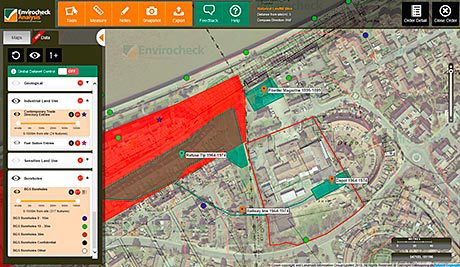
A new edition of the online software tool Envirocheck Analysis became available in August, allowing concurrent access to current AND historic maps in addition to aerial photography and environmental data, streamlining the Phase 1 analysis process of Environmental Site Assessments.
The software suite has been designed to fully digitise the desk study process of these assessments, which are conducted for land and property developments.
According to Landmark Information Group, a UK supplier of digital mapping, property and environmental risk information, which developed the tool, the new Envirocheck Analysis enables environmental consultants to work within a single online platform, accurately assessing environmental risk factors related to a piece of land, without the need to overlay printed maps, manually draw boundaries or search through rafts of printed reports for potential sources, pathways or receptors of contamination.
Early customer feedback on the new Envirocheck Analysis platform has suggested that the time it takes to conduct the data analysis process is reduced by at least 25%, says LIG.
Commenting on the launch, Richard Puttock, Partner of Peter Brett Associates LLP said: “Envirocheck Analysis is really changing the way that we conduct our Phase 1 Site Assessments. In the past, we have ordered our environmental data and historical map reports through Envirocheck and spent our time analysing PDF reports and even printing the documents out to have physical copies to work through. Since adopting Envirocheck Analysis, we are already saving significant amounts of time in analysing historical mapping, and the measuring and drawing tools provide a great level of accuracy, in much less time. Continues Richard Puttock: “We have been involved in the entire user testing phase for the new Envirocheck Analysis, and we can’t wait to start using it for all our Phase 1 desk studies. With all of Envirocheck’s environmental data layers being added into the application, we no longer have to spend so long identifying symbols on maps and relating ID numbers back to separate datasheet reports.
Now we can visualise everything in [ the tool ], alongside current and historical mapping, and make an assessment on the potential risk in much less time. Ultimately, this allows us to complete the job more efficiently without comprising accuracy or quality, which helps us provide an even better service to our clients.” More detail at www.envirocheckanalysis.co.uk/


