

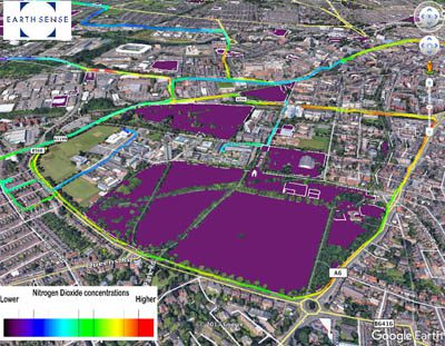
A project combining Ordnance Survey (OS) geospatial data with real-time air quality data from EarthSense Systems is set to highlight clean cycle routes in Britain’s cities.
Using a network of fixed and static air pollution sensors, EarthSense is producing city-wide visualisations of air quality. Combined with OS’s open dataset of greenspaces, the EarthSense air quality models highlight areas of higher air pollution, often along busy roads, and allow users to identify cleaner air routes, such as through parks or along canal paths.
“By making it easy for cyclists to see pollution levels before they make their journey, we can help them make better decisions about their route,” commented Professor Roland Leigh, Technical Director of EarthSense. “This maximises the gain they are getting from the exercise whilst minimising their exposure to harmful pollution.”
Air pollution is the world’s largest single environmental health risk, according to the World Health Organisation, with 80 percent of the world’s population living in cities that exceed its standards for pollution. Air pollution in the UK has been described as a ‘public health emergency’ and levels of nitrogen dioxide (NO2), emitted mostly by diesel vehicles, have been above legal limits in almost 90% of urban areas since 2010.
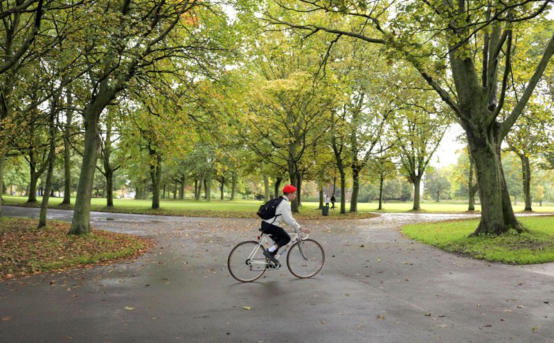
A recent survey has shown that, in the last few years, the number of people who cycle at least once a week has increased by more than 100,000, with more than two million adults regularly cycling. Cycling to work has been promoted as a way to beat train fare rises, while the 2016 Central Statistics Office Commuting in Ireland report showed an increase of 43 percent of people using their bikes to get to work.
Using data from a city wide network of sensors, including the EarthSense state-of-the-art Zephyr sensor, EarthSense captures real time air quality measurements. Combined with other inputs, including satellite observations, weather conditions and traffic emission data in its MappAir modelling solution, EarthSense can deliver data for forecasting, master planning and identifying cleaner cycle routes. The data is available hourly, with a forecast up to three days, and historically, with resolutions ranging from 1m for detailed study areas to 10m for full city maps, and 100m for the national picture.
The OS Open Greenspace product, used to communicate the EarthSense modelled air quality levels, accurately depicts the location and extent of recreational and leisure facilities. Features included in the data are parks, play spaces, golf courses, allotments and more. The comprehensive national dataset is designed to help communities and businesses create solutions that encourage healthier and greener lifestyles. In addition, the greenspace information can be viewed through the popular OS Maps app to help people to discover greenspaces in their local area.
Phillip Wyndham, Strategic Development Manager at the Ordnance Survey, added, “EarthSense delivers a powerful data visualisation of air pollution levels within a city. The data provides clear information to the public, allowing them to make decisions on the best, and cleanest, walking and cycling routes to take. At OS, we are actively encouraging everyone to get outside, and this is another great tool to enable people to discover the greenspaces in our towns and cities.
“The insights gained from such modelling can also be used by policy makers and city planners to make practical interventions around mitigating hot spots – such as traffic light phasing, coordination of streetworks or correctly maintained urban trees and hedges which can trap many harmful pollutants. Data visualisation with a geospatial backdrop is a powerful way to analyse and display data from other third-party sources, and this is exactly the type of innovation which OS OpenData is designed to support.”
EarthSense Systems is a joint venture between aerial mapping company Bluesky and the University of Leicester.


