


A new project will draw upon satellite data to identify problems with underground water pipes, and improve operational efficiencies for water utilities.
Suez describes MasterPlan as the latest product from satellite-based infrastructure intelligence firm Utilis, and provides a deployable pipe deficiency data layer. It is an evolution of the same technology used to find leaks underground using synthetic aperture radar (SAR) sensors. MasterPlan provides actionable insights to utility asset management plans, says the firm.
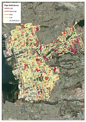
Based on five years and thousands of validated Utilis leak location points of interest, the new MasterPlan algorithm assesses the deficiency of an entire pipe system using multiple SAR images taken months apart. The trained algorithm scores pipe segments based on observed non-surfacing leaks and provides a single GIS dataset of pipes scored from one to five (level of deficiency observed) for easy input into any GIS system or asset planning model.
Nick Haskins, Business Development Manager for SUEZ commented: “Using data obtained from satellites has proven effective in detecting drinking water leaks and we are delighted that the Utilis team have been able to take their algorithm to the next level and provide analytics to help water companies make better decisions when deciding which pipes to replace or rehabilitate.”
MasterPlan is an actual, not predictive, measurement of non-surfacing pipe leaks, making it unique in the industry of asset management modeling data sets where most are based on pipe attributes (such as age and material) or history (such as location and number of breaks). It is available to current Suez customers of Utilis’s pipe leak detection service and new customers alike.


