

Edinburgh-based tech firm Earth Blox says it has demonstrated its ability to provide near-instantaneous cloud powered access and analysis of satellite imagery in a no-code user interface, “opening access to Earth observation (EO) data to non-experts of every sector like never before”.
The capability was demonstrated during a widely-attended Google Earth webinar. Earth Blox says it will empower businesses “to translate raw satellite data into actionable insights in areas such as monitoring climate change, tracking deforestation, and speeding up the response time of natural disasters”.
Launched in 2019, Earth Blox says it seeks to make “EO data accessible to all those that work, live and breathe sustainability”, as CEO Genevieve Patenaude put it.
“This ambition is in good shape as the company secured a partnership with Planet in early 2022, adding high-quality, daily refresh to its available data sets,” said a press release. “Earth Blox has shattered multiple barriers to entry for new users by removing the need for expensive software, lengthy training, as well as the download and processing times for the petabytes of data involved in EO. Building on the ubiquity of global cloud services, Earth Blox makes EO data accessible from the web browser of any tablet or laptop.”
The firm has also entered a partnership with Google.
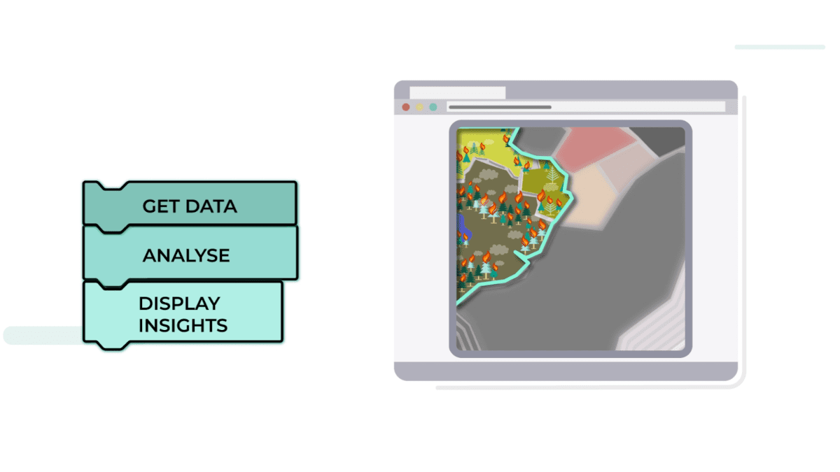
Earth Blox says the web-based software is designed to help customers make better, faster decisions in critical situations with bespoke analysis and action-oriented information visualisation. A “simple yet powerful toolkit empowers users with no coding experience to meet their informational needs, using a drag-and-drop system of re-arrangeable, pre-programmed commands, represented as blocks, to design workflows with specific data sets, analyses and output visualisation parameters”.
“This unique blend of customizability and ease of use is unprecedented in the downstream EO market thanks to Earth Blox’s elegant solution.”
Professor Iain Woodhouse, co-founder of Earth Blox, demonstrated the value of the service to attendees, showing how it has helped over 130 UN country teams with humanitarian and environmental missions.
A climate and environment risk platform designed for the United Nations Environment Program (UNEP), STRATA, has been developed in collaboration with the University of Edinburgh, and is powered by Earth Blox’s technology. STRATA uses “Climate and Environmental Hazards”, “Peace and Security” and “Socio-Economic Exposure” as indicators, assigning values to each and flagging them when they cross a set threshold. Earth Blox’s visual programming environment allows on-site teams to adjust the data input into the platform to reflect the particularities of their region or local situation to identify “hot spots” in a map and identify the most at-risk areas.
This new model of EO delivered in a software-as-a-service (SaaS) package seemingly breaks the mould of how satellite data is normally delivered to users, and “presents groundbreaking opportunities for organisations worldwide to easily track and act on their environmental and sustainability performance as well as that of their suppliers against their own performance indicators”.
The visual programming environment allows new users to quickly familiarise themselves with satellite imagery to leverage a custom workflow, says Earth Blox, helping them identify priority areas for high-impact resource deployment in humanitarian and environmental projects.
The technology is available via https://www.earthblox.io/ and across multiple licenses, including a commercial license and heavily-discounted NGO/Charity as well as Educational Licences. Contact team@EarthBlox.io for more information.


