

HIGH resolution aerial photomaps and laser-surveyed 3D terrain maps from Bluesky are being used to plan and implement vital moorland restoration work in England’s most visited national park.
Purchased by the Moors for the Future Partnership, on behalf of the National Trust, with funding from Defra’s Catchment Restoration Fund, the digital map data is being used as part of this new Peatland Restoration Project to monitor changes in the landscape over time and plan essential works such as peat restoration, gully blocking and reestablishment of vegetation.
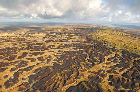
“As most of our work is on a large scale, across a rugged moorland landscape, aerial datasets are really the only way to view projects in context,” commented Tia Crouch, Research Assistant at the Moors for the Future Partnership. “We already hold LiDAR laser mapped data from 2004 and aerial photography so with the 2013 data captured by Bluesky we can compare and contrast changes that have occurred in the landscape as a result of large-scale bare peat restoration work and gully blocking. This enables us to evidence vital moorland conservation work which brings benefits to water quality, carbon store, wildlife and landscape.”
The Moors for the Future Partnership purchased the data from Bluesky following Defra funding from the Catchment Restoration Fund (CRF). The (CRF) was created to clean up England’s rivers; reducing the pollution that comes from the way the land is used and improving the landscape through which water flows. To date a total of £24.5 million pounds has been awarded and it is hoped that over 300 water bodies will receive habitat improvement; improving access for wildlife and reducing pollution. This project is the largest CRF project in the UK and the only one focused on upland / moorland restoration.


