
Unmanned aerial vehicles can make an important contribution to gathering data from flood events, and estimating the damage to properties. Dr Monica Rivas Casaldo, a senior lecturer in integrated environmental monitoring at Cranfield University, offers further insight
Drones have got themselves a bad name as a ‘pest’ of the air. Dutch police have even trained eagles to take down illegal drones (leading to interest from the Metropolitan Police); Japan uses aerial nets to clear rogue drones; a US technology firm sells a drone ‘death-ray’ to airports. In the UK, a new ‘Drone Code’ came into force at the end of July 2018, criminalising people who, for example, fly a drone over 400 feet, or within 1km of an airport’s boundaries.
The danger is that illicit use of UAVs (unmanned aerial vehicles) has tainted both public and official attitudes and undermines the debate on practical applications – which are many, particularly when it comes to their role in environmental monitoring. In a context like river and sea systems, involving large extents of territory which are by their nature always in motion, ever-changing, it’s UAVs that can provide a new solution to the old challenges around access, getting real-time information when it’s needed, and allowing a better understanding of macro-scale trends and events.
Initial trials have shown how UAVs could form an essential part of mapping waterways, providing an unbiased assessment. Capturing high resolution images provides a strong basis for river management, restoration and river quality regulatory frameworks, tracking change, problems and improvements in response to interventions from landowners and authorities.
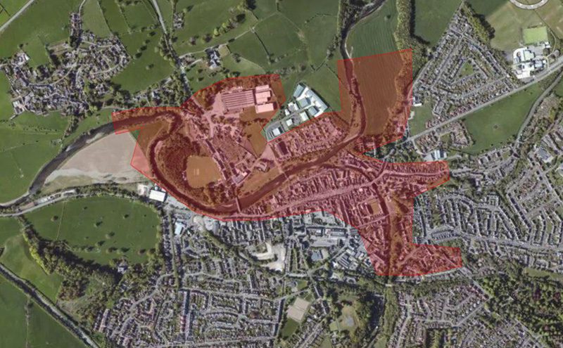
The major flooding in the north of England in the winter of 2016 was a clear demonstration of their practical value. I visited Cockermouth in Cumbria, one of the worst affected areas at the time of the flooding. In the midst of the chaos it was possible to identify with high accuracy the flood damage using UAV flights. The work was carried out as part of a larger ‘Drone Watch’ project commissioned by the Natural Environment Research Council. The Civil Aviation Authority (CAA) had given permission to carry out survey works over any congested space in the UK with a range of 1000m from the pilot.
The average annual cost of flood damage to property in England is more than £1 billion and rising. One in six properties are at risk, and the average cost of the repairs for each property ranges between £10,000 and £50,000. It’s a cycle of threats, misery and repairs that’s exacerbated by the time involved in assessing costs for insurance claims. Residential and commercial property owners are advised not to undertake any clearing up activity until the damage has been assessed by the insurance company, which are time-consuming and costly to undertake. There can be substantial further costs if any dwellings become un-inhabitable and the residents have to move into alternative accommodation.
Limitations of current methods
Current flood damage assessment by the insurance industry following an event relies on a combination of door-to-door inspections and remote sensing techniques. Many Canadian insurers, fro example, use satellite imagery pre- and post-event to assess risk exposure, estimate the number of claims in an area and assess the need for loss adjusters. Similarly, Swiss Re relies on CatNet, a software system that overlays satellite images onto Google maps enabling an assessment of the extent of the flooded area to be made and to determine where claims will arise. But there are a number of factors that limit the effectiveness of remote sensing methods: spatio-temporal coverage may not be available for the required zone and period; optical imagery cannot provide information if there is low cloud cover; satellite data that can penetrate cloud cover has an oblique viewing angle which makes it difficult to discriminate water from other urban features. Also, current remote sensing approaches don’t provide enough detail to assess the effects of micro-topography in streets and the presence of property flood resistance measures.
An analysis of the data from Cockermouth has demonstrated the potential of UAVs as a more effective alternative. UAV aerial imagery offers both timely (on-demand) and increasingly detailed (higher resolution) information than comparable satellite or aircraft imagery. UAVs can also be deployed to assist in the response to flooding in conditions and areas that are not accessible by manned aircraft or helicopters. In the last five years, the use of UAV technology has increased exponentially with a varied range of commercial platforms (rotary blade, fixed wing, and nano and hybrid drones) and sensors. An estimated 600 UAVs were used globally in 2015 by police, firefighters, humanitarian relief, and disaster management, with the number being used doubling on a yearly basis.
As a result of storm Desmond, a total of 466 properties were flooded due to flood risk management structures being overtopped and outflanked. The event was a consequence of heavy rainfall over an extended period with more than 300 mm of rain falling over a 24 hour period, which translated into flows in the Derwent River of 395 m3s−1 at the Ouse Bridge gauging station and 170 m3s−1 at the Cocker Southwaite River station. The estimated annual exceedance probability for the observed event was less than 1% for both rainfall and river flows.
UAV specifications
A fixed wing platform UAV was selected for the survey to maximize area coverage under the rainy and gusty conditions. The Sirius-Pro platform had a 163 cm wingspan and a length of 120 cm, able to fly for up to 50 minutes, and equipped with a 16-megapixel Panasonic GX-1 on-board camera. Images were used to identify the flood impact and extent, with each point being assigned a confidence level (high, medium, or low) describing the uncertainty associated with its impact classification and the potential for the impact to have been generated from any other source rather than flood. The raw UAV high-resolution imagery was used to reduce the level of uncertainty when possible. The resulting flood impact point database was used to identify residential property that could have been flooded during Desmond.
The direct tangible losses (domestic clean-up, household inventory damage, and building fabric damage) for the affected properties were calculated using a UK specific methodology. The losses (without VAT or other indirect taxes) for a residential property of a given type and age were estimated based on the flood water depth within the property. Residential properties with directly observable resistance measures (i.e., flood aperture guards for doors and windows, flood resistant airbricks, and raised doors or steps leading to a property) were also taken into account, alongside the type of flooding (overbank topping, pluvial run-off, and groundwater) affecting the property.
UAV analysis results
The results from the UAV analysis were compared with those from the classic door-to-door approach (assumed to deliver 100% accuracy). The UAV framework was found to provide an accuracy in the detection of flooded properties of 84%. The results also highlighted the importance of considering all sources of flooding even when an event is largely thought to be fluvial in nature. It is important in the initial evaluation of an event to consider flooding from all sources not just from the overtopping of flood risk management structures. There were significant levels of pluvial and lateral flow flooding, with a total of £3.6 million in direct tangible losses assigned to 168 properties outside the fluvial flood extent. This comprises 36% of the total direct tangible losses associated with all sources of flooding in Cockermouth during this event. These properties were not initially identified as being flooded as the initial responses focused on the fluvial flood extent. Resistance measures present within the area resulted in a considerable reduction in direct tangible losses (£4 million). The work presented here also highlighted the importance in selecting accurate remote sensing loss-adjustment approaches, with a discrepancy in direct tangible losses between the two approaches tested of around £1 million.
The UAV approach will facilitate a better and faster estimation of the extent and impact of a flooding event, a more rapid evaluation of the affected area and the associated damage costs, also enabling loss adjusters to prioritise their individual household impact assessments. What’s needed now is further development of the system to allow for a more automated process and near-real-time data.
The lessons from this work are now been shared with the Indian government as part of its national action planning in response to severe flooding.
UAV monitoring can play an essential role in understanding and addressing specific challenges in water-based operations. For example, coastal nuclear power stations are increasingly becoming plagued by dense accumulations of jellyfish and seaweed as a result of changes in sea temperature and currents, which can clog water intakes – a situation where the monitoring capabilities of UAVs can play a role in minimising opertional disruption (see the longer, online version of this article for more detail).
The full potential of UAVs in environmental monitoring is only now being explored. But it’s clear there are new sets of skills needed by professionals in the area: UAV flight control, data capture, image processing and data interpretation.
• This piece has been adapted from a research article previously published in Remote Sensing 2018.


